
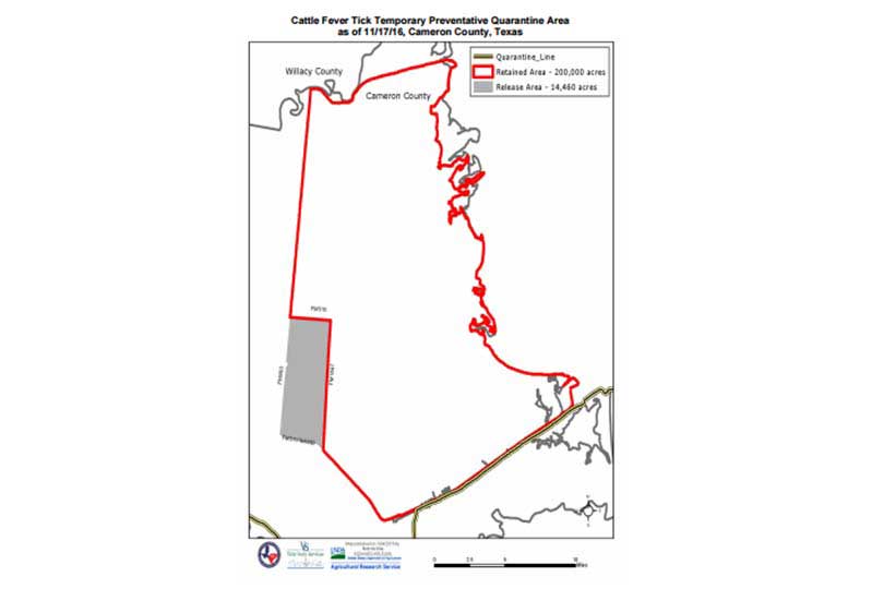
The Texas Animal Health Commission (TAHC) has modified the 223,000-acre Temporary Preventative Quarantine Area (TPQA) in Cameron County.
The TPQA was established two years ago when cattle fever ticks were discovered on cattle, horses, white-tailed deer and nilgai antelope.
Through enhanced surveillance of the area, TAHC has now determined 14,460 acres located in the southwest corner of the TPQA meets requirements for quarantine release. The modified TPQA will consist of about 200,000 acres.
Although the TPQA is being reduced, TAHC and the U.S. Department of Agriculture continue to closely monitor and respond to the expansion and northward movement of fever ticks.
There are currently 17 individual cattle fever tick infested premises in Cameron County, 19 in infested Willacy County premises, two infested Kleberg County premises and 45 infested premises in the permanent quarantine zone along the Texas-Mexico border.
Within the TPQA, permanent quarantined zone, and on quarantined premises, all cattle, equine and live or hunted wildlife—nilgai antelope and white-tailed deer—that are capable of hosting fever ticks, are subject to movement restrictions, inspections and treatment as prescribed by TAHC fever tick regulations.
To read the regulations, visit Title 4, Chapter 41 of the Texas Administrative Code.
To learn more about hunting in a temporary or permanent fever tick quarantine zone, visit the TAHC YouTube channel.
The Temporary Preventative Quarantine Area as of Nov. 17, 2016 is within the boundaries of a line beginning at appoint in Cameron County where FM 511 and Captain Donald L. Foust Road intersect (25.950997;-97.412259); thence, northwest along FM 511 for 6.15 miles to FM 1847 (26.014478; -97.481208); thence, north along FM 1847 for 7.94 miles to FM 510 (26.129494; – 97.471077); thence, west along FM 510 for 2.89 miles to FM 803 (26.132970; – 97.517470); thence, north along FM 803 for 14.01 miles to FM 2925 (26.335137; – 97.491350); thence, east along FM 2925 for 7.28 miles to the east side of the Adolph Thomae Jr. County Park eastern-most parking lot (26.349462; -97.390468) (parking lot); thence, north along side of the parking lot for 61.3 yards to the Arroyo Colorado (26.349960; -97.390577); thence, east along the Arroyo Colorado shoreline for 4.45 miles to Laguna Madre (26.353917; -97.325179); thence, southeast along the Laguna Madre shoreline for 55.33 miles to the Brownsville Navigation District Ship Channel (26.064276; -97.775511) (Brownsville Ship Channel); thence, southwest along the Brownsville Ship Channel for 16.4 miles to the point on Windhaus Road that is a straight line southwest of the Brownsville Ship Channel (25.952057; -97.403765); thence, north along Windhaus Road for .1 mile to Captain Donald L. Foust Road (25.952738; -97.404135); thence, west along Captain Donald L. Foust Road for .52 miles to FM 511 (25.950997; -97.412259), the beginning.
For questions regarding livestock or wildlife inspections, please call 956-443-6609.
Click here to learn more about fever ticks.