
By Jennifer Dorsett
Field Editor
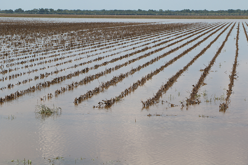
In 2017, Hurricane Harvey devastated Texas with the amount of costly damage and historic flooding it brought to the state.
Over a four-day period, many parts of the Lone Star State received more than 40 inches of rain, with some areas seeing as much as 60 inches. To date, Harvey is the wettest tropical cyclone on record in the U.S.
During the next biennial legislative session in 2019, Texas lawmakers passed SB 8, Texas’ first-ever regionalized state flood planning process.
Now, the Texas Water Development Board (TWDB) has been tasked with overseeing the first state flood plan and the fifth operational flood plan for the state, Reem Zoun, TWDB director of Flood Planning Division, said.
“There have been advances on flash flood-related technologies all over the world, but what we’re trying to do here in the state of Texas is quite unique,” Zoun said. “We’re trying to look at statewide flood plains and come up with ways to reduce the risk of flooding and protect life and property against the risk of flooding.”
The 15 regional flood planning groups are self-governing, Zoun said. So, they will be under local control and collaboration. River basin-based groups are supposed to ensure there is no negative impact to neighboring communities.
Groups will be responsible for developing Texas’ first set of regional flood plans, due by January 2023. Those flood plans will come together as the state flood plan in 2024. Zoun said funds will be provided to planning groups to hire technical consultants to assist in the process.
Each area will work to identify specific progressive action goals and an acceptable level of risk and will conduct flood hazard analyses, which Zoun said is a three-step process.
“The first step is to identify where the risk is, extent of the risk, the frequency of the risk, how often this might happen,” she said. “And if it happens, how deep is it going to be? We know that some parts of Texas, like some of the bigger cities—Houston, Fort Worth, Dallas, San Antonio, Austin—they prob-ably have flood mapping done. But Texas is a fairly large state, and there are a lot of rural areas that we don’t have data on.”
Further analysis involves determining who is at risk, including residents and critical facilities such as fire departments, police stations, hospitals and schools. Once the information has been gathered, Zoun said the groups will identify evaluations and projects that will be needed in the future.
TWDB’s executive administrator is taking nominations through July 17 for planning group members.
Each planning group will have 12 voting members, and an ideal candidate will have experience in and an interest in working cooperatively on public issues and be committed to and possess expertise in flood risk-related issues.
The candidates should be “strongly affiliated with and endorsed by the flood risk category” in which they seek nomination: agricultural interest, industries, river authorities, counties, municipalities, water districts, flood districts, electric-generating utilities, public, water utilities, environmental interests or small business.
The agricultural interest members will be responsible for representing agriculture in flood planning goals. Zoun said it is important to have representatives on each board to prevent ideas that would be harmful to farmers and ranchers from being incorporated into the state flood plan.
“For example, in water detention areas, you can accumulate flood water and then relieve it,” she said. “But that may not be applicable to agriculture. If a crop is underwater for a certain amount of time, that causes harm to those crops. And what is acceptable risk?”
The agency hopes to hold the first set of meetings in October.
“There’s been a lot of work related to the reduction of flood risk in the state of Texas, but statewide, it has never come together,” Zoun said. “Bringing the state together, bringing the regions together and having a comprehensive sense of the risk and knowing what we’re doing to address it and where we’re not doing enough is going to serve everyone very well.”
Click here to read more about the flood planning groups, see a map of the 15 designated regions and to download the nomination form.