
By Jessica Domel
Multimedia Reporter
After a weak and short-lived La Niña, we have moved back to a neutral weather pattern, and it looks like that may continue through the rest of the year.
“Getting into the forecast, one thing we look at is the state of the equatorial Pacific, which is where we look for La Niña or El Niño. It’s such a small patch of ocean, but it really controls a lot of the weather patterns downstream to the north and east, including much of North America,” Brad Rippey, meteorologist for the U.S. Department of Agriculture (USDA), said.
El Niño and La Niña are two opposing weather patterns seen in the equatorial Pacific that the National Oceanic and Atmospheric Administration (NOAA) reports can have global impacts on weather, wildfires, ecosystems and economies.
El Niño is a warming of the waters, and La Niña is a cooling.
El Niño typically brings cooler and wetter than average weather to Texas while La Niña brings warmer and drier weather.
“The current status for that La Niña zone in the central and eastern equatorial Pacific shows El Niño/Southern Oscillation (ENSO) neutral conditions. We’ve come out of La Niña,” Rippey said. “It was short-lived and weak, but it did influence weather patterns over the winter across North America.”
Because of La Niña, we have seen warmer-than-normal sea surface temperatures since the last El Niño.
That has contributed to generally above-average temperatures globally over the past few years, according to Rippey.
“As we look at the forecast for the rest of this year, we are expecting ENSO neutral conditions. Right now, we are ENSO neutral. We expect those odds to stay greater than 50% through August, September and October,” Rippey said.
There is a chance for another La Niña later this year.
“By the time we get to the end of calendar year 2025, we do have some odds of a bounce back. La Niña odds get up near 40%, but we have slightly higher odds of ENSO neutral conditions,” Rippey said. “Could we go back into La Niña this fall? Yes, it’s a possibility, but it’s not a certainty by any stretch as we head into this growing season.”
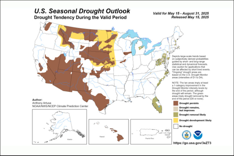
Right now, meteorologists are watching the western and central United States for the possibility of drought expansion or intensification, Rippey said.
He expects consistently hot conditions along and west of a line from Montana to the Southern Plains.
“Heat could contribute to an active western wildfire season,” Rippey said.
Moving toward the end of May and into the early parts of the summer, Rippey said we could see a ridge of high pressure forming over the northwestern United States that consolidates hot, dry weather in that area.
Long-range forecast tools show wetness developing in the Eastern U.S. even before the start of hurricane season.
Rippey said if you draw a line at the Rocky Mountains, it looks to be hotter to the west and cooler to the east.
“Looking ahead a little further, in August, September and October, it still looks like a hot forecast for the western U.S., possibly in the deep south and east, as well,” Rippey said.
As for hurricane season, it looks to be less active on the west coast.
NOAA forecasts a 30% chance of below-normal tropical cyclone activity for the upcoming central Pacific Hurricane Season.
“The 2025 outlook also indicates a 50% chance of a near-normal hurricane season and a 20% chance that it will be above-normal,” according to NOAA.
The administration’s Atlantic hurricane outlook will be released Thursday, May 22.
Colorado State University released its hurricane forecast for the year. Rippey said it calls for 17 named storms, nine hurricanes and four major hurricanes.
Leave A Comment