
By Jessica Domel
Multimedia Editor
A bill designed to help private property owners along the Red River protect their land from federal overreach was passed by the U.S. House of Representatives Tuesday.
The bill, The Red River Gradient Boundary Survey Act (HR 428), was introduced by U.S. Congressman Mac Thornberry.
“This bill essentially requires the Bureau of Land Management (BLM) to do what they should have done all along. Its passage in the House is an important step toward providing these landowners with the legal certainty they deserve. I hope we can use this momentum to get the bill passed in the Senate and then signed into law by the president,” Thornberry said. “I will continue working with the landowners, local and state officials and Senator (John) Cornyn until this issue is resolved once and for all.”
It passed the House in a 250-171 vote.
Cornyn has introduced a companion bill in the Senate.
“(The) vote is a big step forward for Texas families that have owned land along the Red River for generations,” Cornyn said. “I want to thank Congressman Thornberry for ushering this bill through the House and bringing us closer to protecting Texans from baseless claims the federal government has made to their property.”
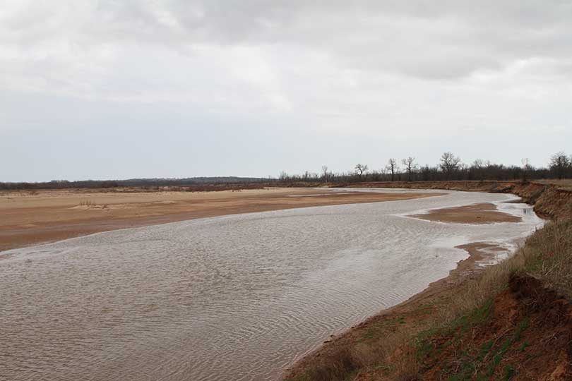
The legislation seeks to end questions about the federal government’s claim to 116 miles of land along the Red River.
“Private property owners should never have to worry about the federal government coming in to take away their land, especially land that has never been properly surveyed. Our bills will help provide these property owners the certainty that they deserve to know where public lands end and private lands begin,” Thornberry said.
The federal Bureau of Land Management (BLM) expressed a claim to the land in 2008 while surveying the area. Their claim stems from a decades-old dispute regarding the movement of the Red River and where Texas ends and Oklahoma begins.
As part of that dispute, a strip of land between the two states is claimed by the federal government. The BLM claims that over time, because of the movement of the river, that land has grown and is federal property, which is overseen by the BLM.
As a result, the men and women who have cared for and paid taxes on the land inside the 116-mile stretch for years are now in limbo regarding their property.
They hope legislation like the bills filed by Thornberry and Cornyn will offer relief.
“Texas landowners should not have to worry about the federal government coming in and taking away land that they have lawfully owned and paid taxes on for years, especially when the government has not conducted a proper survey,” U.S. Representative Jodey Arrington said of the legislation.
If passed, the legislation will:
- Commission a survey of the entire 116-mile stretch of contested area along the Red River using the gradient boundary survey method developed and backed by the Supreme Court to find the proper ownership boundary between public and private land.
- Order that the survey be conducted by licensed and qualified surveyors chosen by Texas and Oklahoma.
- Provide states the authority to oversee the surveyors and approve the final survey to ensure the Supreme Court instructions are properly followed.
- Require that a notice of survey approval, a copy of the survey, and any related field notes be provided to each individual landowner after the survey is completed.
- Ensure that nothing in the bill alters the Red River Boundary Compact, modifies the interests of the states or harms the rights of the impacted federally recognized Indian tribes.
The legislation is a modified version of bills filed by Thornberry and Cornyn in previous legislative sessions.
According to Thornberry, the new bills take into account input by landowners, the General Land Office and others involved.
Texas Farm Bureau has been working to address the issue on two fronts—in the courtroom and the capitol—to help affected landowners.
A group of the landowners has filed a lawsuit against the federal
Next it’ll be a survey of our southern border river………
No survey necessary. The feds will just “take” what they need to build the wall.
I bring to the attention of the editor the use of the term “afflicted” in this article. The article is being presented as a piece of reporting and not an editorial expressing the views of the author. The term afflicted has connotations of suffering due to an illness or troubled by a situation. In a piece of reporting journalism it is the author’s responsibility to produce the facts and not inject the author’s feelings in the piece. The term more suited to a non emotional report of facts would have been “affected” which invokes the idea that the landowners have a stake in the process, however, it leaves out the emotional tone of injury which is editorial.